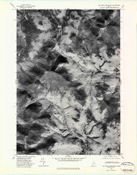
1977 Map of Old Speck Mountain
USGS Topo · Published 1983About this map
Old Speck Mountain and Baldpate Mountain dominate this late 1970s orthophotoquad, which uses aerial photography from the U.S. Geological Survey to show the unpopulated, high-elevation terrain of Oxford County. Unlike traditional topographic maps, this imagery reveals the actual density of forest cover and the stark transitions in the landscape where mountain peaks give way to deep drainage basins. The drainage network is clearly visible through the shadows and textures of the terrain, with the Swift Cambridge River and Bear River cutting through the northern and central sections of the quadrangle. These watercourses, along with Bull Branch and Goose Eye Brook, define the natural corridors through this region, showing no significant human settlement or development at the time of the photography. This orthophotograph is particularly valuable for understanding the true vegetation patterns and topographic relief of this part of the Maine mountains.
Find a feature on this map
7 named features on this map. Tap any name to fly to it.
Don’t see what you’re looking for? This feature index may not catch every label — zoom into the map to look around manually.
Map Details
Editions of this 1977 Old Speck Mountain Map
This is the sole edition of this map. No revisions or reprints were ever made.
Other maps of this area

1893 · Gorham
USGS Topo · 1:62,500

1896 · Gorham
USGS Topo · 1:62,500

1914 · Bethel
USGS Topo · 1:62,500

1930 · Milan
USGS Topo · 1:62,500

1933 · Milan
USGS Topo · 1:62,500

1934 · Milan
USGS Topo · 1:62,500

1937 · Gorham
USGS Topo · 1:48,000

1940 · Bethel
USGS Topo · 1:62,500

1941 · Bethel
USGS Topo · 1:62,500

1942 · Gorham
USGS Topo · 1:62,500
Featured Places
- Newry, ME
- Grafton Township, ME
- Andover West Surplus Township, ME
- Riley Township, ME
- Ketchum, Riley Township