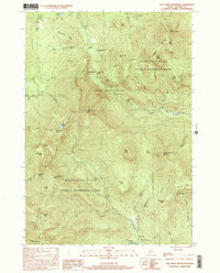
2000 Map of Old Speck Mountain
USGS Topo · Published 2001About this map
Old Speck Mtn and the high peaks of the Mahoosucs State Public Reserved Land dominate this survey of the Oxford backcountry. The landscape is defined by the steep glacial cut of Grafton Notch, where the Bear River flows past geological landmarks like Moose Cave, Mother Walker Falls, and Screw Auger Falls. The Appalachian National Scenic Trail winds through the center of the sheet, connecting Speck Pond with the formidable Mahoosuc Notch and several high summits including Mahoosuc Arm and Fulling Mill Mtn. To the south, the terrain descends toward the Sunday River valley and the small settlement at Ketchum near the Newry boundary. This provisional edition documents the extensive protected lands and trail networks as they existed at the turn of the millennium, highlighting the remote character of the northern Mahoosucs.
Find a feature on this map
54 named features on this map. Tap any name to fly to it.
Don’t see what you’re looking for? This feature index may not catch every label — zoom into the map to look around manually.
Map Details
Editions of this 2000 Old Speck Mountain Map
This is the sole edition of this map. No revisions or reprints were ever made.
Other maps of this area

1893 · Gorham
USGS Topo · 1:62,500

1896 · Gorham
USGS Topo · 1:62,500

1914 · Bethel
USGS Topo · 1:62,500

1930 · Milan
USGS Topo · 1:62,500

1933 · Milan
USGS Topo · 1:62,500

1934 · Milan
USGS Topo · 1:62,500

1937 · Gorham
USGS Topo · 1:48,000

1940 · Bethel
USGS Topo · 1:62,500

1941 · Bethel
USGS Topo · 1:62,500

1942 · Gorham
USGS Topo · 1:62,500
Featured Places
- Newry, ME
- Grafton Township, ME
- Andover West Surplus Township, ME
- Riley Township, ME
- Ketchum, Riley Township