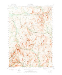
1943 Map of Old Speck Mtn
USGS Topo · Published 1972About this map
Grafton Notch serves as a central passage through this mountainous terrain of Oxford County, as recorded by a 1943 survey. The landscape is defined by the high peaks of the Mahoosuc Range, including the prominent summit of Old Speck Mtn featuring its Fire Tower. The Appalachian Trail winds through these heights, passing through Mahoosuc Notch and over Sunday River Whitecap. The topography is shaped by significant water features such as Mother Walker Falls and Screw Auger Falls along the river valleys.
Find a feature on this map
114 named features on this map. Tap any name to fly to it.
Don’t see what you’re looking for? This feature index may not catch every label — zoom into the map to look around manually.
Map Details
Editions of this 1943 Old Speck Mtn Map
4 editions found

Other maps of this area

1893 · Gorham
USGS Topo · 1:62,500

1896 · Gorham
USGS Topo · 1:62,500

1911 · Bryant Pond
USGS Topo · 1:62,500

1914 · Bethel
USGS Topo · 1:62,500

1914 · Bryant Pond
USGS Topo · 1:62,500

1927 · Rumford
USGS Topo · 1:48,000

1930 · Rumford
USGS Topo · 1:62,500

1930 · Milan
USGS Topo · 1:62,500

1930 · Errol
USGS Topo · 1:62,500

1933 · Rangeley
USGS Topo · 1:48,000