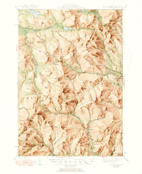
1945 Map of Old Speck Mtn
USGS Topo · Published 1950About this map
Old Speck Mtn and the surrounding peaks of the Mahoosuc Range dominate this mid-century survey of the Maine wilderness. The landscape is defined by its dramatic relief, featuring prominent passes such as Grafton Notch and Sawyer Notch that navigate the high terrain. Human presence is concentrated in small pockets like North Newry and the North Newry P O, while the interior remains primarily the domain of timber interests and early recreationists. The Appalachian Trail winds through the topography, connecting peaks like Baldpate Mtn and Saddleback Mtn.
Find a feature on this map
115 named features on this map. Tap any name to fly to it.
Don’t see what you’re looking for? This feature index may not catch every label — zoom into the map to look around manually.
Map Details
Editions of this 1945 Old Speck Mtn Map
4 editions found

Other maps of this area

1893 · Gorham
USGS Topo · 1:62,500

1896 · Gorham
USGS Topo · 1:62,500

1911 · Bryant Pond
USGS Topo · 1:62,500

1914 · Bethel
USGS Topo · 1:62,500

1914 · Bryant Pond
USGS Topo · 1:62,500

1927 · Rumford
USGS Topo · 1:48,000

1930 · Rumford
USGS Topo · 1:62,500

1930 · Milan
USGS Topo · 1:62,500

1930 · Errol
USGS Topo · 1:62,500

1933 · Rangeley
USGS Topo · 1:48,000