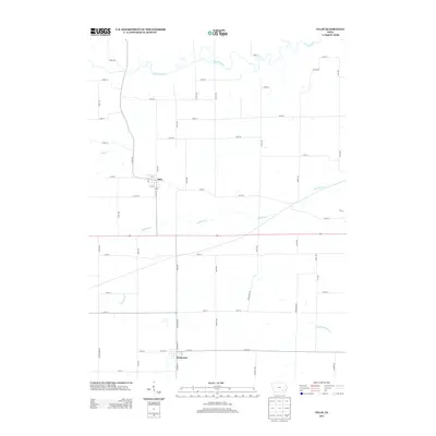
2013 Map of Ollie
USGS Topo · Published 2013About this map
Ollie and Packwood anchor this Southeast Iowa landscape, where the agricultural grid meets the winding courses of the Skunk River and its southern branch. The map illustrates a rural environment defined by sectional roads and the drainage patterns of Richland Cr and Rock Cr. In the northern portion of the sheet, the S Skunk River carves a meandering path that disrupts the rigid geometry of the county road system, creating a pocket of varied terrain in an otherwise uniform prairie landscape. The southern edge is marked by the small settlement of Packwood, showing its street layout and proximity to Middle Walnut Cr. This 2013 digital survey provides a precise view of the modern rural infrastructure, including secondary routes like Co Rd V5G, during a period of continued reliance on traditional town centers and family farm connections.
Find a feature on this map
57 named features on this map. Tap any name to fly to it.
Don’t see what you’re looking for? This feature index may not catch every label — zoom into the map to look around manually.
Map Details
Editions of this 2013 Ollie Map
This is the sole edition of this map. No revisions or reprints were ever made.
Other maps of this area

1954 · Des Moines
USGS Topo · 1:250,000

1956 · Des Moines
USGS Topo · 1:250,000

1957 · Des Moines
USGS Topo · 1:250,000

1958 · Davenport
USGS Topo · 1:250,000

1961 · Davenport
USGS Topo · 1:250,000

1962 · Davenport
USGS Topo · 1:250,000

1965 · Harper
USGS Topo · 1:24,000

1965 · Sigourney
USGS Topo · 1:24,000

1969 · Des Moines
USGS Topo · 1:250,000
1973 · Keota
USGS Topo · 1:24,000