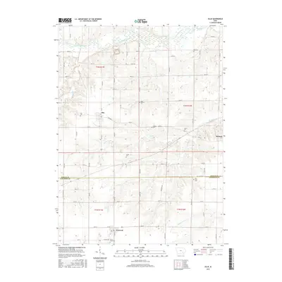
2015 Map of Ollie
USGS Topo · Published 2015About this map
South Skunk River meanders across the northern portion of this landscape, carving a wide valley through the agricultural heartland of Keokuk and Jefferson counties. The settlement patterns follow a strict rectangular grid, anchored by the towns of Ollie, Richland, and Packwood. The map reveals a high density of rural burial grounds, which serve as critical markers of early pioneer lineage and township organization. These include family and community sites like Reed Cem, Altman Cem, and Blue Point Cem, many located near the winding tributaries of Richland Cr and Middle Walnut Cr. The topography is defined by the gentle drainage systems that feed into the larger Skunk River basin, creating a distinct contrast between the flat upland farms and the more textured creek bottoms.
Find a feature on this map
66 named features on this map. Tap any name to fly to it.
Don’t see what you’re looking for? This feature index may not catch every label — zoom into the map to look around manually.
Map Details
Editions of this 2015 Ollie Map
This is the sole edition of this map. No revisions or reprints were ever made.
Other maps of this area

1954 · Des Moines
USGS Topo · 1:250,000

1956 · Des Moines
USGS Topo · 1:250,000

1957 · Des Moines
USGS Topo · 1:250,000

1958 · Davenport
USGS Topo · 1:250,000

1961 · Davenport
USGS Topo · 1:250,000

1962 · Davenport
USGS Topo · 1:250,000

1965 · Harper
USGS Topo · 1:24,000

1965 · Sigourney
USGS Topo · 1:24,000

1969 · Des Moines
USGS Topo · 1:250,000
1973 · Keota
USGS Topo · 1:24,000