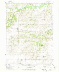
1980 Map of Ollie
USGS Topo · Published 1981About this map
The South Skunk River meanders across the northern portion of this landscape, its banks punctuated by the Manhattan Bridge County Park and an active Quarry. This 1980s record captures the transition of the region's transportation network, where the active Chicago Milwaukee St Paul and Pacific line runs parallel to an Old Railroad Grade that once connected these small Iowa agrarian centers. The town of Ollie serves as a central hub, surrounded by a dense distribution of rural burial grounds such as Ollie Cem, Brethren Cem, and Hafferty Cem, which provide significant data for local genealogical research. To the south, the settlement of Packwood sits near Middle Walnut Creek, marking the boundary between Keokuk and Jefferson counties. The placement of the South Keokuk Ch and numerous family-named cemeteries reflects a deeply rooted community structure established long before the modern highway system dominated the area.
Find a feature on this map
28 named features on this map. Tap any name to fly to it.
Don’t see what you’re looking for? This feature index may not catch every label — zoom into the map to look around manually.
Map Details
Editions of this 1980 Ollie Map
This is the sole edition of this map. No revisions or reprints were ever made.
Other maps of this area

1954 · Des Moines
USGS Topo · 1:250,000

1956 · Des Moines
USGS Topo · 1:250,000

1957 · Des Moines
USGS Topo · 1:250,000

1958 · Davenport
USGS Topo · 1:250,000

1961 · Davenport
USGS Topo · 1:250,000

1962 · Davenport
USGS Topo · 1:250,000

1965 · Harper
USGS Topo · 1:24,000

1965 · Sigourney
USGS Topo · 1:24,000

1969 · Des Moines
USGS Topo · 1:250,000
1973 · Keota
USGS Topo · 1:24,000