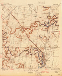
1945 Map of Olmito
USGS Topo · Published 1945About this map
Resaca de los Cuates and Resaca de la Palma dominate this landscape, their winding oxbow channels tracing the ancient path of the Rio Grande through Cameron County. The map captures an era of agricultural development and rail dependency, with the Missouri Pacific railroad serving as the primary corridor for shipping. Small trackside communities and sidings like Barreda, Crigler, and Cavazos Siding illustrate the distribution of labor and logistics in the Rio Grande Valley.
Find a feature on this map
29 named features on this map. Tap any name to fly to it.
Don’t see what you’re looking for? This feature index may not catch every label — zoom into the map to look around manually.
Map Details
Editions of this 1945 Olmito Map
This is the sole edition of this map. No revisions or reprints were ever made.
Other maps of this area

1929 · Rio Hondo
USGS Topo · 1:24,000

1929 · Harlingen
USGS Topo · 1:24,000

1929 · La Paloma
USGS Topo · 1:24,000

1930 · Los Fresnos
USGS Topo · 1:24,000

1930 · West Brownsville
USGS Topo · 1:24,000

1930 · Barreda
USGS Topo · 1:24,000

1930 · Laguna Atascosa
USGS Topo · 1:24,000

1930 · East Brownsville
USGS Topo · 1:24,000

1932 · Rio Hondo
USGS Topo · 1:31,680

1932 · Harlingen
USGS Topo · 1:31,680