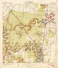
1936 Map of Olmito
USGS Topo · Published 1936About this map
The ancient distributary channels of the Rio Grande delta dominate this 1930s landscape of southern Cameron County, appearing as the winding, serpentine oxbows of Resaca de los Cuates, Resaca del Rancho Viejo, and Resaca de la Palma. This era represents a significant period of agricultural development, where the Missouri Pacific railroad corridor and State Highway No 4 provided the backbone for settlements like Olmito and Barreda. The land is divided into numbered tracts and garden roads, including Iowa Gardens Road, reflecting the irrigation-driven citrus and vegetable boom of the Lower Rio Grande Valley.
Find a feature on this map
30 named features on this map. Tap any name to fly to it.
Don’t see what you’re looking for? This feature index may not catch every label — zoom into the map to look around manually.
Map Details
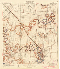
Editions of this 1936 Olmito Map
2 editions found
Other maps of this area

1929 · Rio Hondo
USGS Topo · 1:24,000

1929 · Harlingen
USGS Topo · 1:24,000

1929 · La Paloma
USGS Topo · 1:24,000

1930 · Los Fresnos
USGS Topo · 1:24,000

1930 · West Brownsville
USGS Topo · 1:24,000

1930 · Barreda
USGS Topo · 1:24,000

1930 · Laguna Atascosa
USGS Topo · 1:24,000

1930 · East Brownsville
USGS Topo · 1:24,000

1932 · Rio Hondo
USGS Topo · 1:31,680

1932 · Harlingen
USGS Topo · 1:31,680