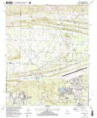
1996 Map of Olmstead
USGS Topo · Published 1999About this map
Little Rock Air Force Base dominates the southeastern quadrant of this Pulaski County landscape, showing the complex layout of runways, housing, and operational facilities like the Arnold Drive School and Water Treatment Plant. To the north and west, the terrain transitions into a more rural pattern of ridges and creek valleys. Notable high ground including Backbone Ridge and Mill Erving Ridge separates the drainage of Bayou Meto and Little Creek. Small communities and historic gathering points are scattered throughout, such as Olmstead, Warsaw, and the site of Tates Mill. The map documents a dense network of local landmarks, from the Harmony Church in the west to the Zion Hill Church in the northeast. This 1990s survey records the balance between military infrastructure and the long-standing agricultural settlements that define the region north of Jacksonville.
Find a feature on this map
89 named features on this map. Tap any name to fly to it.
Don’t see what you’re looking for? This feature index may not catch every label — zoom into the map to look around manually.
Map Details
Editions of this 1996 Olmstead Map
This is the sole edition of this map. No revisions or reprints were ever made.
Other maps of this area

1891 · Little Rock
USGS Topo · 1:125,000

1893 · Little Rock
USGS Topo · 1:125,000

1935 · Mc Almont
USGS Topo · 1:24,000

1935 · North Little Rock
USGS Topo · 1:24,000

1941 · Olmstead
USGS Topo · 1:31,680

1941 · Cabot
USGS Topo · 1:31,680

1943 · Jacksonville
USGS Topo · 1:31,680

1953 · Cato
USGS Topo · 1:24,000

1954 · Mc Almont
USGS Topo · 1:24,000

1954 · Olmstead
USGS Topo · 1:24,000