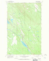
1966 Map of Olney
USGS Topo · Published 1971About this map
The timbered valley of the Stillwater River defines this mid-1960s survey, centered on the small community of Olney in the Stillwater State Forest. This period shows the town as a vital stop along the Great Northern railroad, which runs parallel to the river and connects the scattered settlements of the region. The landscape is a mosaic of open meadows and forest, with many meadows bearing local names like Ritsenburg Meadow, Skunk Meadow, and Round Meadow, suggesting a long history of grazing or early homesteading in these clearings.
Find a feature on this map
35 named features on this map. Tap any name to fly to it.
Don’t see what you’re looking for? This feature index may not catch every label — zoom into the map to look around manually.
Map Details
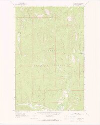
Editions of this 1966 Olney Map
This is the sole edition of this map. No revisions or reprints were ever made.
Other maps of this area

1906 · Kintla Lakes
USGS Topo · 1:125,000

1913 · Stryker
USGS Topo · 1:125,000

1916 · Stryker
USGS Topo · 1:125,000

1938 · Kintla Lakes
USGS Topo · 1:125,000

1943 · Kalispell
USGS Topo · 1:125,000

1957 · Kalispell
USGS Topo · 1:250,000

1960 · Kalispell
USGS Topo · 1:250,000

1961 · Kalispell
USGS Topo · 1:250,000
1962 · Johnson Peak
USGS Topo · 1:24,000
1962 · Beaver Lake
USGS Topo · 1:24,000