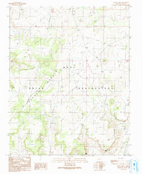
1990 Map of Onion Spring
USGS Topo · Published 1991About this map
The Hopi Indian Reservation landscape is defined by the prominent Second Mesa, which cuts a distinct diagonal path across the western portion of this 1990 survey. Water sources, vital for life in this arid region, are marked by the namesake Onion Spring in the north and Goat Spring further south. The drainage patterns are anchored by Wepo Wash in the southeast, where it flows past landmarks like Meat Point. Human interaction with the land is visible through a network of unimproved roads, multiple cattle corrals, and infrastructure like a Check Dam and a Drill Hole. This provisional manuscript reflects the terrain as documented in the mid-1960s and updated through the 1980s, preserving a record of Navajo County land use before significant modern development.
Find a feature on this map
11 named features on this map. Tap any name to fly to it.
Don’t see what you’re looking for? This feature index may not catch every label — zoom into the map to look around manually.
Map Details
Editions of this 1990 Onion Spring Map
This is the sole edition of this map. No revisions or reprints were ever made.
Other maps of this area

1883 · Marsh Pass
USGS Topo · 1:250,000

1883 · Tusayan
USGS Topo · 1:250,000

1886 · Tusayan
USGS Topo · 1:250,000

1892 · Marsh Pass
USGS Topo · 1:250,000

1947 · Flagstaff
USGS Topo · 1:250,000

1954 · Flagstaff
USGS Topo · 1:250,000

1956 · Marble Canyon
USGS Topo · 1:250,000

1958 · Flagstaff
USGS Topo · 1:250,000

1959 · Marble Canyon
USGS Topo · 1:250,000

1960 · Flagstaff
USGS Topo · 1:250,000