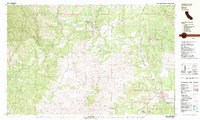
1981 Map of Ono
USGS Topo · Published 1981About this map
Ono serves as a central point in this early 1980s landscape, situated where Platina Road crosses the North Fork Cottonwood Creek. The map documents a rugged Shasta County terrain defined by the Bald Hills and the winding course of the Roaring River. Local mining history is evident at the Blue Gravel Mine, where extensive Tailings are marked along the creek beds, signifying the enduring impact of hydraulic or placer operations on the local geography. To the east, Gas Point and the nearby Gaging Station indicate a transition toward more managed water resources, including the Happy Valley Ditch. The presence of small, isolated locales like Poverty and Wiley Flat illustrates the dispersed settlement pattern typical of this region’s foothills, while the local Cem near the confluence of Middle Fork Cottonwood Creek provides a tangible link for those researching the families who worked these drainages and hillsides.
Find a feature on this map
37 named features on this map. Tap any name to fly to it.
Don’t see what you’re looking for? This feature index may not catch every label — zoom into the map to look around manually.
Map Details
Editions of this 1981 Ono Map
2 editions found
Other maps of this area

1890 · Red Bluff
USGS Topo · 1:250,000

1894 · Red Bluff
USGS Topo · 1:250,000

1901 · Redding
USGS Topo · 1:125,000

1913 · Weaverville
USGS Topo · 1:125,000

1932 · Olinda
USGS Topo · 1:31,680

1935 · Olinda
USGS Topo · 1:31,680

1944 · Redding
USGS Topo · 1:62,500

1944 · French Gulch
USGS Topo · 1:62,500

1946 · Redding
USGS Topo · 1:62,500

1947 · Anderson
USGS Topo · 1:62,500