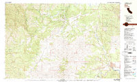
1981 Map of Ono
USGS Topo · Published 1981About this map
The small settlement of Ono sits at the northern end of this 1981 survey, where the North Fork Cottonwood Creek meets the rugged drainage of Jerusalem Creek. The landscape is defined by the Bald Hills to the south and a complex network of gulches and creeks, including Roaring River and Crow Creek, that flow toward the Middle Fork Cottonwood Creek. Evidence of the region's hydraulic and mining history is visible along the waterways, most notably at the Blue Gravel Mine and several areas of tailings near the junction of Cottonwood Creek.
Find a feature on this map
35 named features on this map. Tap any name to fly to it.
Don’t see what you’re looking for? This feature index may not catch every label — zoom into the map to look around manually.
Map Details
Editions of this 1981 Ono Map
2 editions found
Other maps of this area

1890 · Red Bluff
USGS Topo · 1:250,000

1894 · Red Bluff
USGS Topo · 1:250,000

1901 · Redding
USGS Topo · 1:125,000

1913 · Weaverville
USGS Topo · 1:125,000

1932 · Olinda
USGS Topo · 1:31,680

1935 · Olinda
USGS Topo · 1:31,680

1944 · Redding
USGS Topo · 1:62,500

1944 · French Gulch
USGS Topo · 1:62,500

1946 · Redding
USGS Topo · 1:62,500

1947 · Anderson
USGS Topo · 1:62,500