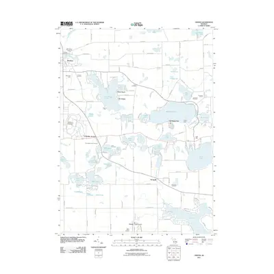
2011 Map of Onsted
USGS Topo · Published 2011About this map
Vineyard Lake and Wamplers Lake anchor this recreational and residential landscape, which reflects decades of development around the region's numerous glacial kettles. The village of Brooklyn sits in the northwest corner, where the River Raisin flows near the Brooklyn Cemetery. To the south, the settlement of Onsted serves as a local hub, anchored by the Onsted Post Office and Maple Shade Cemetery. The map captures a high density of seasonal and year-round communities such as Sunset Beach, The Heights, and Oak Shade Park, which ring the shorelines of larger water bodies.
Find a feature on this map
149 named features on this map. Tap any name to fly to it.
Don’t see what you’re looking for? This feature index may not catch every label — zoom into the map to look around manually.
Map Details
Editions of this 2011 Onsted Map
This is the sole edition of this map. No revisions or reprints were ever made.
Other maps of this area

1935 · Jackson
USGS Topo · 1:48,000

1939 · Jackson
USGS Topo · 1:62,500

1948 · Manchester
USGS Topo · 1:62,500

1949 · Manchester
USGS Topo · 1:62,500

1953 · Fort Wayne
USGS Topo · 1:250,000

1956 · Fort Wayne
USGS Topo · 1:250,000

1958 · Grand Rapids
USGS Topo · 1:250,000

1961 · Grand Rapids
USGS Topo · 1:250,000

1962 · Grand Rapids
USGS Topo · 1:250,000
1962 · Adrian
USGS Topo · 1:24,000