
1948 Map of Manchester
USGS Topo · Published 1972About this map
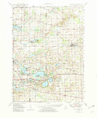
The Raisin River meanders through this portion of southeastern Michigan, connecting the industrial hub of Manchester with the smaller lakeside communities of Norvell and Brooklyn. This 1940s landscape is defined by its extensive water system, where natural lakes like Wamplers Lake and Vineyard Lake sit alongside engineered features such as the Iron Mill Pond and Norvell Lake. The geography reflects a mid-century transition as agricultural townships like Sharon and Franklin maintained a high density of rural schoolhouses, including Sharon Hill Sch and English Sch, even as recreation began to dominate around Hayes State Park.
Find a feature on this map
124 named features on this map. Tap any name to fly to it.
Don’t see what you’re looking for? This feature index may not catch every label — zoom into the map to look around manually.
Map Details
Editions of this 1948 Manchester Map
2 editions found
Other maps of this area

1902 · Dexter
USGS Topo · 1:62,500

1904 · Ann Arbor
USGS Topo · 1:125,000

1906 · Dexter
USGS Topo · 1:62,500

1906 · Saline
USGS Topo · 1:62,500

1908 · Ann Arbor
USGS Topo · 1:125,000

1919 · Stockbridge
USGS Topo · 1:62,500

1919 · Rives Junction
USGS Topo · 1:62,500

1921 · Rives Junction
USGS Topo · 1:62,500

1922 · Stockbridge
USGS Topo · 1:62,500

1935 · Jackson
USGS Topo · 1:48,000