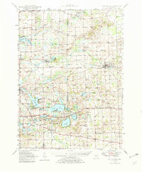
1948 Map of Manchester
USGS Topo · Published 1982About this map
The Raisin River winds through this post-war landscape, anchoring the village of Manchester in Washtenaw County. This 1948 survey shows a region defined by its numerous glacial lakes and the agricultural and transport networks that connected them. The New York Central railroad serves as a primary corridor, passing through settlements like Napoleon and Norvell. To the south, the recreational draw of the area is evident at Hayes State Park, situated between Wamplers Lake and Round Lake. The map reveals a dense network of early rural infrastructure, including dozens of small schoolhouses like Spafard Sch and Bradley Sch, many of which were the civic centers for their respective townships. Unique landmarks such as Brooklyn Memorial Airport and the Girl Scout Camp on Stony Lake illustrate the transition of this territory from purely agrarian roots to a mid-century destination for leisure and local aviation.
Find a feature on this map
105 named features on this map. Tap any name to fly to it.
Don’t see what you’re looking for? This feature index may not catch every label — zoom into the map to look around manually.
Map Details
Editions of this 1948 Manchester Map
2 editions found

Other maps of this area

1902 · Dexter
USGS Topo · 1:62,500

1904 · Ann Arbor
USGS Topo · 1:125,000

1906 · Dexter
USGS Topo · 1:62,500

1906 · Saline
USGS Topo · 1:62,500

1908 · Ann Arbor
USGS Topo · 1:125,000

1919 · Stockbridge
USGS Topo · 1:62,500

1919 · Rives Junction
USGS Topo · 1:62,500

1921 · Rives Junction
USGS Topo · 1:62,500

1922 · Stockbridge
USGS Topo · 1:62,500

1935 · Jackson
USGS Topo · 1:48,000