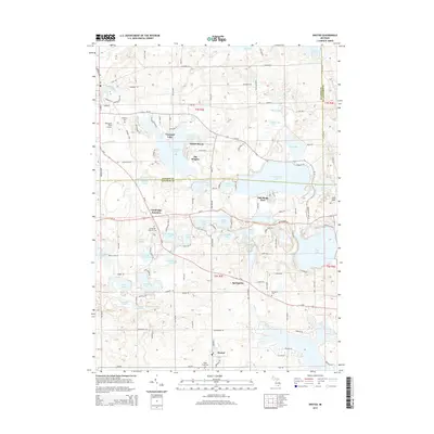
2014 Map of Onsted
USGS Topo · Published 2014About this map
Irish Hills rise above a landscape defined by an intricate network of glacial lakes and wetlands at the intersection of Jackson, Lenawee, and Washtenaw counties. The settlement of Onsted anchors the southern portion of the map, while the northern reaches are dominated by recreation and residential clusters around Vineyard Lake, Sunset Beach, and The Heights. The historic corridor of the Monroe Pike and Us-12 passes through Cambridge Junction, a site marked by the Cambridge Junction Cem. Water is the primary geographic feature, from the headwaters of the River Raisin to large basins like Wamplers Lake and Sand Lake. This era shows a well-established network of rural roads and cemeteries, including Maple Shade Cem and Springville Cem, which provide essential touchstones for researchers tracking early families in the vicinity of Springville and the surrounding township.
Find a feature on this map
136 named features on this map. Tap any name to fly to it.
Don’t see what you’re looking for? This feature index may not catch every label — zoom into the map to look around manually.
Map Details
Editions of this 2014 Onsted Map
This is the sole edition of this map. No revisions or reprints were ever made.
Other maps of this area

1935 · Jackson
USGS Topo · 1:48,000

1939 · Jackson
USGS Topo · 1:62,500

1948 · Manchester
USGS Topo · 1:62,500

1949 · Manchester
USGS Topo · 1:62,500

1953 · Fort Wayne
USGS Topo · 1:250,000

1956 · Fort Wayne
USGS Topo · 1:250,000

1958 · Grand Rapids
USGS Topo · 1:250,000

1961 · Grand Rapids
USGS Topo · 1:250,000

1962 · Grand Rapids
USGS Topo · 1:250,000
1962 · Adrian
USGS Topo · 1:24,000