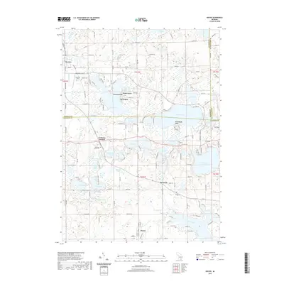
2019 Map of Onsted
USGS Topo · Published 2019About this map
Irish Hills rise across the center of this landscape, anchoring a lake-rich region on the border of Jackson and Lenawee Counties. The glacial terrain is defined by a dense cluster of water bodies including Wamplers Lake, Vineyard Lake, and the winding River Raisin. Small lakeside settlements like Sunset Beach and The Heights suggest a long-established recreation and residential pattern centered on these shores. Local history is grounded in numerous community sites, from the crossroads at Cambridge Junction to several burial grounds like Cambridge Junction Cem and Springville Cem. The map reveals a transition from the village of Brooklyn in the northwest to the organized streets of Onsted in the south, connected by a network of rural roads that navigate around large wetlands and deep-water lakes like Deep Lake and Wolf Lake.
Find a feature on this map
145 named features on this map. Tap any name to fly to it.
Don’t see what you’re looking for? This feature index may not catch every label — zoom into the map to look around manually.
Map Details
Editions of this 2019 Onsted Map
This is the sole edition of this map. No revisions or reprints were ever made.
Other maps of this area

1935 · Jackson
USGS Topo · 1:48,000

1939 · Jackson
USGS Topo · 1:62,500

1948 · Manchester
USGS Topo · 1:62,500

1949 · Manchester
USGS Topo · 1:62,500

1953 · Fort Wayne
USGS Topo · 1:250,000

1956 · Fort Wayne
USGS Topo · 1:250,000

1958 · Grand Rapids
USGS Topo · 1:250,000

1961 · Grand Rapids
USGS Topo · 1:250,000

1962 · Grand Rapids
USGS Topo · 1:250,000
1962 · Adrian
USGS Topo · 1:24,000