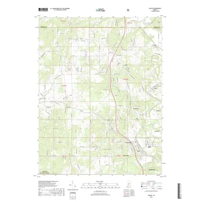
2019 Map of Oolitic
USGS Topo · Published 2019About this map
Oolitic and East Oolitic serve as central points in this landscape just north of Bedford, where the terrain is marked by significant geographic depressions including Dark Hollow and Diehl Hollow. The area is densely populated with small settlements and rural nodes like Needmore, Peerless, and Murdock, reflecting a long-standing limestone-related industrial and residential pattern along the Salt Creek corridor. Numerous family and community burial grounds, such as Hopkins Cem, Mount Zion Cem, and the Springville Christian Cem, are distributed across the landscape, providing valuable locations for genealogical research. The southern boundary reaches into the Hoosier National Forest, contrasting with the more developed residential clusters near Patton Hill and Guthrie. This survey provides a clear view of the complex road network, from named rural lanes like Pierce Cemetery Ln to the corridors connecting Avoca and Judah.
Find a feature on this map
156 named features on this map. Tap any name to fly to it.
Don’t see what you’re looking for? This feature index may not catch every label — zoom into the map to look around manually.
Map Details
Editions of this 2019 Oolitic Map
This is the sole edition of this map. No revisions or reprints were ever made.
Other maps of this area

1908 · Bloomington
USGS Topo · 1:48,000

1910 · Bloomington
USGS Topo · 1:62,500

1934 · Bedford
USGS Topo · 1:48,000

1935 · Oolitic
USGS Topo · 1:48,000

1937 · Bedford
USGS Topo · 1:62,500

1942 · Franklin
USGS Topo · 1:125,000

1942 · Oolitic
USGS Topo · 1:62,500

1947 · Allens Creek
USGS Topo · 1:24,000

1953 · Indianapolis
USGS Topo · 1:250,000

1956 · Indianapolis
USGS Topo · 1:250,000