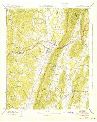
1941 Map of Ooltewah
USGS Topo · Published 1941About this map
Whiteoak Mountain dominates the center of this Tennessee Valley Authority and Geological Survey study, creating a dramatic barrier between the growing communities of the 1940s. The Southern Railway traverses this difficult terrain, passing through Dead Man Gap to connect Ooltewah with the eastern valleys. To the south, Collegedale serves as a cultural hub, anchored by the campus of Southern Junior College.
Find a feature on this map
79 named features on this map. Tap any name to fly to it.
Don’t see what you’re looking for? This feature index may not catch every label — zoom into the map to look around manually.
Map Details
Editions of this 1941 Ooltewah Map
This is the sole edition of this map. No revisions or reprints were ever made.
Other maps of this area

1886 · Dalton
USGS Topo · 1:125,000

1886 · Cleveland
USGS Topo · 1:125,000

1886 · Ringgold
USGS Topo · 1:125,000

1888 · Chattanooga
USGS Topo · 1:125,000

1892 · Ringgold
USGS Topo · 1:125,000

1892 · Cleveland
USGS Topo · 1:125,000

1892 · Dalton
USGS Topo · 1:125,000

1893 · Chattanooga
USGS Topo · 1:125,000

1895 · Cleveland
USGS Topo · 1:125,000

1897 · Dalton
USGS Topo · 1:125,000