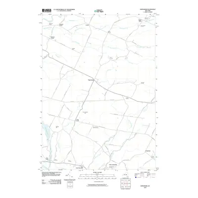
2010 Map of Oppenheim
USGS Topo · Published 2010About this map
Saint Johnsville sits at the southern edge of this landscape, positioned along the historic transport corridor of the Mohawk River. Moving north from the river valley, the terrain rises toward the agricultural and forested uplands of Oppenheim, where the road network connects smaller settlements such as Middle Sprite and Lotville. The map reveals a high density of rural burial grounds, including the Middlesprite Cemetery, Saint Bridgett's Cemetery, and the Dutch Reformed Church Cemetery, which speak to the long-established family lineages of Herkimer County. Numerous waterways, including East Canada Creek and Crum Creek, drain the territory, while landmarks like Twin Church Hill and Failing Hill provide topographical variation. This 2010 survey documents the enduring rural character of the region, where older homesteads and local roads like Youkers Bush Rd and Irish Settlement Rd maintain the historical footprint of early New York settlement.
Find a feature on this map
80 named features on this map. Tap any name to fly to it.
Don’t see what you’re looking for? This feature index may not catch every label — zoom into the map to look around manually.
Map Details
Editions of this 2010 Oppenheim Map
This is the sole edition of this map. No revisions or reprints were ever made.
Other maps of this area

1898 · Canajoharie
USGS Topo · 1:62,500

1900 · Little Falls
USGS Topo · 1:62,500

1900 · Canajoharie
USGS Topo · 1:62,500

1901 · Lassellsville
USGS Topo · 1:62,500

1902 · Canajoharie
USGS Topo · 1:62,500

1903 · Richfield Springs
USGS Topo · 1:62,500

1903 · Lassellsville
USGS Topo · 1:62,500

1903 · Little Falls
USGS Topo · 1:62,500

1939 · Little Falls
USGS Topo · 1:62,500
1943 · Little Falls
USGS Topo · 1:24,000