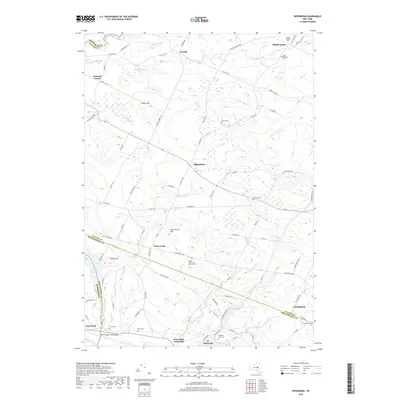
2019 Map of Oppenheim
USGS Topo · Published 2019About this map
The valley of the Mohawk River anchors the southern boundary of this region, where the town of St. Johnsville and its nearby neighbor West Saint Johnsville serve as historic hubs along the water. Moving north into the uplands, the landscape transitions into a series of smaller agricultural settlements like Oppenheim, Crum Creek, and Lotville. The terrain is defined by a network of drainages including East Canada Creek and Middle Sprite Cr that cut through the hills. For family historians, the area is notably dense with small burying grounds such as the Dutch Reformed Church Cem, Klock Cem, and Saint Bridgetts Cem, reflecting the early lineage of Herkimer, Fulton, and Montgomery counties. The presence of East Canada Lake and prominent heights like Sweet Hill illustrate the geographic character of this Central New York crossroads during the early 21st century.
Find a feature on this map
89 named features on this map. Tap any name to fly to it.
Don’t see what you’re looking for? This feature index may not catch every label — zoom into the map to look around manually.
Map Details
Editions of this 2019 Oppenheim Map
This is the sole edition of this map. No revisions or reprints were ever made.
Other maps of this area

1898 · Canajoharie
USGS Topo · 1:62,500

1900 · Little Falls
USGS Topo · 1:62,500

1900 · Canajoharie
USGS Topo · 1:62,500

1901 · Lassellsville
USGS Topo · 1:62,500

1902 · Canajoharie
USGS Topo · 1:62,500

1903 · Richfield Springs
USGS Topo · 1:62,500

1903 · Lassellsville
USGS Topo · 1:62,500

1903 · Little Falls
USGS Topo · 1:62,500

1939 · Little Falls
USGS Topo · 1:62,500
1943 · Little Falls
USGS Topo · 1:24,000