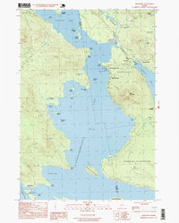
1997 Map of Oquossoc
USGS Topo · Published 1999About this map
Mooselookmeguntic Lake and Cupsuptic Lake dominate this survey of the Rangeley Lakes region during the late 1990s. The settlement of Oquossoc serves as a central hub, situated near the confluence of the Kennebago River and the Rangeley Grade. This map captures a landscape defined by traditional Maine sporting heritage, illustrated by the presence of the Oquossoc Angling Assn and numerous boat landings.
Find a feature on this map
47 named features on this map. Tap any name to fly to it.
Don’t see what you’re looking for? This feature index may not catch every label — zoom into the map to look around manually.
Map Details
Editions of this 1997 Oquossoc Map
This is the sole edition of this map. No revisions or reprints were ever made.
Other maps of this area

1931 · Cupsuptic
USGS Topo · 1:48,000

1932 · Kennebago Lake
USGS Topo · 1:48,000

1933 · Rangeley
USGS Topo · 1:48,000

1934 · Cupsuptic
USGS Topo · 1:62,500

1935 · Kennebago Lake
USGS Topo · 1:62,500

1935 · Cupsuptic
USGS Topo · 1:62,500

1936 · Kennebago Lake
USGS Topo · 1:62,500

1939 · Rangeley
USGS Topo · 1:62,500

1940 · Oquossoc
USGS Topo · 1:62,500

1942 · Oquossoc
USGS Topo · 1:62,500
Featured Places
- Rangeley, ME
- Rangeley Plantation, ME
- Adamstown Township, ME
- Upper Dam, Richardsontown Township
- Pleasant Island, Adamstown Township