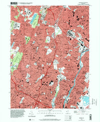
1995 Map of Orange
USGS Topo · Published 2000About this map
The Watchung Mountain ridgeline dominates this dense urban and suburban landscape, where the Cedar Grove Reservoir sits between the first and Second Watchung Mountain. The map illustrates the intensive development of Essex County, from the residential neighborhoods of Montclair and Glen Ridge to the industrial corridors along the Passaic River. Historical preservation and public land use are evident at the Thomas A Edison Nat Hist Site and the expansive Eagle Rock Reservation. This survey captures a transportation-heavy era where the Erie Railroad and Garden State Parkway serve as primary arteries through established boroughs like Bloomfield and Belleville. Numerous institutional landmarks, such as Overbrook Hospital and the State Teachers College, appear alongside a high density of religious centers including Beth Torah Temple and Sacred Heart Cathedral.
Find a feature on this map
177 named features on this map. Tap any name to fly to it.
Don’t see what you’re looking for? This feature index may not catch every label — zoom into the map to look around manually.
Map Details
Editions of this 1995 Orange Map
This is the sole edition of this map. No revisions or reprints were ever made.
Other maps of this area

1888 · Plainfield
USGS Topo · 1:62,500

1888 · Morristown
USGS Topo · 1:62,500

1888 · Paterson
USGS Topo · 1:62,500

1892 · Paterson
USGS Topo · 1:62,500

1893 · Plainfield
USGS Topo · 1:62,500

1894 · Morristown
USGS Topo · 1:62,500

1898 · Morristown
USGS Topo · 1:62,500

1898 · Plainfield
USGS Topo · 1:62,500

1898 · Staten Island
USGS Topo · 1:62,500

1898 · Paterson
USGS Topo · 1:62,500