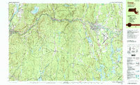
1990 Map of Orange
USGS Topo · Published 1990About this map
The Millers River corridor serves as the industrial and transportation backbone of this North Quabbin region during the 1990s, connecting the population center of Orange with outlying settlements like Erving and Farley. The river valley is shared by the Boston and Maine RR and the Mohawk Trail, illustrating a historical reliance on the narrow, carved lowlands for east-west movement through the hilly Franklin County terrain. To the south, the landscape is defined by the massive Quabbin Reservoir and its protected watersheds, including the New Salem State Forest. Local genealogists will find several burial grounds such as Mount Hope Cem and Holton Cem, alongside established landmarks like the Orange Municipal Airport and Mahar High Sch. This map documents a high density of public lands, where the wooded uplands of Erving State Forest and Wendell State Forest hem in the riverine villages.
Find a feature on this map
56 named features on this map. Tap any name to fly to it.
Don’t see what you’re looking for? This feature index may not catch every label — zoom into the map to look around manually.
Map Details
Editions of this 1990 Orange Map
2 editions found
Other maps of this area

1885 · Northampton
USGS Topo · 1:62,500

1886 · Northampton
USGS Topo · 1:62,500

1887 · Warwick
USGS Topo · 1:62,500

1887 · Belchertown
USGS Topo · 1:62,500

1887 · Winchendon
USGS Topo · 1:62,500

1887 · Barre
USGS Topo · 1:62,500

1889 · Barre
USGS Topo · 1:62,500

1889 · Warwick
USGS Topo · 1:62,500

1890 · Belchertown
USGS Topo · 1:62,500

1890 · Greenfield
USGS Topo · 1:62,500