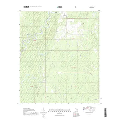
2021 Map of Orange
USGS Topo · Published 2021About this map
The Apalachicola River winds through a dense landscape of wetlands and forests at the intersection of Liberty, Calhoun, and Gulf Counties. This interior Florida wilderness is defined by its complex hydrology, where the main river channel is flanked by a network of backwaters including Brown Lake, Queen City Lake, and Everett Slough. Small settlements like Orange and Lewis are located along the higher ground of the eastern ridges, away from the seasonal floodplains of the Apalachicola National Forest. Local history is anchored by sites such as Orange Cem and Humility Cem, while the riverine economy is reflected in features like Porter Reach and Ricko Bluff. The map illustrates the dominance of the river system over human geography, with roads like Co RD 379 navigating the margins between the river swamps and the pine-upland environments.
Find a feature on this map
55 named features on this map. Tap any name to fly to it.
Don’t see what you’re looking for? This feature index may not catch every label — zoom into the map to look around manually.
Map Details
Editions of this 2021 Orange Map
This is the sole edition of this map. No revisions or reprints were ever made.
Other maps of this area

1945 · Dead Lake
USGS Topo · 1:31,680

1945 · Kennedy Creek
USGS Topo · 1:31,680

1945 · Estiffanulga
USGS Topo · 1:31,680

1945 · Orange
USGS Topo · 1:31,680

1945 · Frink
USGS Topo · 1:31,680

1945 · Wewahitchka
USGS Topo · 1:31,680

1945 · Woods
USGS Topo · 1:31,680

1946 · Sumatra
USGS Topo · 1:31,680
1946 · Wilma
USGS Topo · 1:31,680

1954 · Tallahassee
USGS Topo · 1:250,000