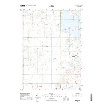
2019 Map of Orangeville
USGS Topo · Published 2019About this map
Gun Lake dominates the northeastern landscape of this region, its complex shoreline defined by points and islands such as Yankee Springs Island and Orangeville Island. The settlement of Orangeville sits just south of the lake's Pickerel Cove, serving as a central point in a territory marked by a high density of small water bodies and family burial grounds. The Gun River drains south through the Gun Plains, passing the small community of Hooper. Genealogists will find a wealth of local history preserved in the numerous cemeteries dotting the township grid, including Oak Hill Cem, Messer Cem, and East Martin Cem. The terrain shifts from the prominent Boot Lake Ridge in the northwest to the low-lying wetlands surrounding England Lake and Mill Pond, illustrating the varied glacial topography of this part of the state.
Find a feature on this map
139 named features on this map. Tap any name to fly to it.
Don’t see what you’re looking for? This feature index may not catch every label — zoom into the map to look around manually.
Map Details
Editions of this 2019 Orangeville Map
This is the sole edition of this map. No revisions or reprints were ever made.
Other maps of this area

1916 · Kalamazoo
USGS Topo · 1:62,500

1918 · Kalamazoo
USGS Topo · 1:62,500

1918 · Galesburg
USGS Topo · 1:62,500

1943 · Kalamazoo
USGS Topo · 1:62,500

1944 · Galesburg
USGS Topo · 1:62,500

1947 · Delton
USGS Topo · 1:24,000

1947 · Galesburg
USGS Topo · 1:62,500

1950 · Galesburg
USGS Topo · 1:62,500

1951 · Hastings
USGS Topo · 1:62,500

1958 · Grand Rapids
USGS Topo · 1:250,000