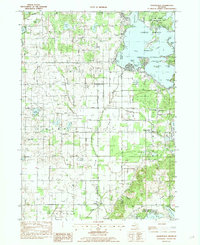
1982 Map of Orangeville
USGS Topo · Published 1982About this map
The Yankee Springs State Recreation Area dominates the northeastern landscape of this map, surrounding the large waters of Gun Lake. This 1982 survey provides a detailed view of the rural settlements and family histories within Allegan and Barry counties, including the community of Orangeville and the Indian Mission near Bradley. The distribution of burial grounds such as Oak Hill Cem, Indian Cem, and Messer Cem offers critical coordinates for genealogists tracing early regional families.
Find a feature on this map
65 named features on this map. Tap any name to fly to it.
Don’t see what you’re looking for? This feature index may not catch every label — zoom into the map to look around manually.
Map Details
Editions of this 1982 Orangeville Map
This is the sole edition of this map. No revisions or reprints were ever made.
Other maps of this area

1916 · Kalamazoo
USGS Topo · 1:62,500

1918 · Kalamazoo
USGS Topo · 1:62,500

1918 · Galesburg
USGS Topo · 1:62,500

1943 · Kalamazoo
USGS Topo · 1:62,500

1944 · Galesburg
USGS Topo · 1:62,500

1947 · Delton
USGS Topo · 1:24,000

1947 · Galesburg
USGS Topo · 1:62,500

1950 · Galesburg
USGS Topo · 1:62,500

1951 · Hastings
USGS Topo · 1:62,500

1958 · Grand Rapids
USGS Topo · 1:250,000
Featured Places
- Orangeville, MI
- Gun Plain Charter Township, MI
- Prairieville Township, MI
- Orangeville Township, MI
- Yankee Springs Township, MI