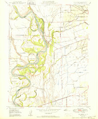
1950 Map of Ord Ferry
USGS Topo · Published 1950About this map
The Sacramento River meanders through a complex network of sloughs and channels in this mid-century survey of the Butte and Glenn county border. This riparian landscape is defined by its hydraulic history, featuring named islands like Phelan Island and Golden State Island alongside the winding Deadmans Reach. The map documents the overlap of traditional Mexican land grants, such as Rancho Llano Seco and Rancho De Farwell, with the more rigid section lines of the Mt Diablo Meridian. Transport and industry are evident in the Southern Pacific rail line and the site of Chico Landing, while the presence of Bidwell State Park and Sutter Bidwell State Park highlights early efforts in conservation along the riverbanks. Scattered landmarks, including Bidwell Sch and various pumping stations, provide key reference points for local genealogists and historians studying the agrarian development of the Sacramento Valley.
Find a feature on this map
60 named features on this map. Tap any name to fly to it.
Don’t see what you’re looking for? This feature index may not catch every label — zoom into the map to look around manually.
Map Details
Editions of this 1950 Ord Ferry Map
This is the sole edition of this map. No revisions or reprints were ever made.
Other maps of this area

1891 · Chico
USGS Topo · 1:125,000

1893 · Chico
USGS Topo · 1:125,000

1895 · Chico
USGS Topo · 1:125,000

1904 · Vina
USGS Topo · 1:62,500

1906 · Willows
USGS Topo · 1:62,500

1912 · Durham
USGS Topo · 1:31,680

1912 · Nord
USGS Topo · 1:31,680

1912 · Chico Landing
USGS Topo · 1:31,680

1912 · Nelson
USGS Topo · 1:31,680

1912 · Keefers
USGS Topo · 1:31,680