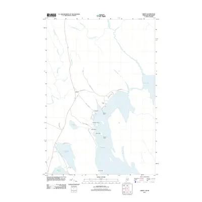
2011 Map of Orient
USGS Topo · Published 2011About this map
The settlement of Orient and the lakeside community of Sunset Park anchor this map of the Maine-New Brunswick borderlands. Situated along the expansive waters of Grand Lake and North Lake, the landscape is defined by its complex shoreline, featuring prominent landmarks like Caribou Point and several named islands including Halfmoon Island, Bear Island, and Burnt Island. The road network provides evidence of historical transit patterns, most notably the path of Old U.S. 1, which runs parallel to the western shores of Longley Lake and Longfellow Lake.
Find a feature on this map
35 named features on this map. Tap any name to fly to it.
Don’t see what you’re looking for? This feature index may not catch every label — zoom into the map to look around manually.
Map Details
Editions of this 2011 Orient Map
This is the sole edition of this map. No revisions or reprints were ever made.
Other maps of this area

1940 · Danforth
USGS Topo · 1:62,500

1940 · Amity
USGS Topo · 1:62,500

1940 · Forest
USGS Topo · 1:62,500

1941 · Danforth
USGS Topo · 1:62,500

1941 · Amity
USGS Topo · 1:62,500

1942 · Forest
USGS Topo · 1:62,500

1943 · Danforth
USGS Topo · 1:62,500

1943 · Amity
USGS Topo · 1:62,500

1957 · Fredericton
USGS Topo · 1:250,000
1958 · Danforth
USGS Topo · 1:62,500