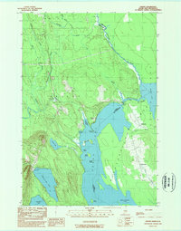
1989 Map of Orient
USGS Topo · Published 1989About this map
The international boundary between the United States and Canada defines this landscape, following the course of Monument Brook into the sprawling Chiputneticook Lakes system. In the late 1980s, this area of southern Aroostook County remained a complex network of waterways and timberlands, with the settlement of Orient positioned between the heights of the interior and the shores of Grand Lake. The map reveals the intricate shoreline of the border region, from MacAllister Cove to the narrow passage known as The Thoroughfare connecting to North Lake. Local recreation and resource extraction are evident through features like Sunset Park, the Campground Boat Launch, and several gravel operations including Graves Pit. Smaller interior bodies of water, such as Longley Lake and Brackett Lake, further illustrate the hydrologic character of the Maine-New Brunswick borderlands.
Find a feature on this map
42 named features on this map. Tap any name to fly to it.
Don’t see what you’re looking for? This feature index may not catch every label — zoom into the map to look around manually.
Map Details
Editions of this 1989 Orient Map
This is the sole edition of this map. No revisions or reprints were ever made.
Other maps of this area

1940 · Danforth
USGS Topo · 1:62,500

1940 · Amity
USGS Topo · 1:62,500

1940 · Forest
USGS Topo · 1:62,500

1941 · Danforth
USGS Topo · 1:62,500

1941 · Amity
USGS Topo · 1:62,500

1942 · Forest
USGS Topo · 1:62,500

1943 · Danforth
USGS Topo · 1:62,500

1943 · Amity
USGS Topo · 1:62,500

1957 · Fredericton
USGS Topo · 1:250,000
1958 · Danforth
USGS Topo · 1:62,500