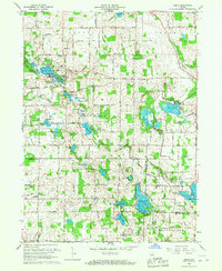
1965 Map of Ormas
USGS Topo · Published 1967About this map
Glacial lakes dominate this landscape in north-central Indiana, where the Tippecanoe River winds through the border between Noble and Whitley counties. The map provides a detailed view of the 1960s shoreline for dozens of named water bodies, including the large Loon Lake, Bear Lake, and the smaller, interconnected Knapp Lake system. Rural life is anchored by small settlements like Ormas and Etna, and a network of country churches such as Broadway Ch and West Etna Community Ch. For genealogists and local researchers, several family and church cemeteries are recorded, including Wolf Lake Cem, Thorn Cem, and Stringtown Cem. A notable geographic feature is the Old Indian Treaty Boundary, which runs diagonally across the northern townships, marking the historical legacy of the 1826 and 1828 treaties. The presence of a Township Sch and multiple gravel pits suggests the local economy of the mid-20th century was tied to both education and the extraction of glacial deposits.
Find a feature on this map
59 named features on this map. Tap any name to fly to it.
Don’t see what you’re looking for? This feature index may not catch every label — zoom into the map to look around manually.
Map Details
Editions of this 1965 Ormas Map
This is the sole edition of this map. No revisions or reprints were ever made.
Other maps of this area

1950 · Pierceton
USGS Topo · 1:24,000

1950 · North Webster
USGS Topo · 1:24,000

1951 · Wawasee
USGS Topo · 1:24,000

1951 · Ormas
USGS Topo · 1:24,000

1951 · Merriam
USGS Topo · 1:24,000

1953 · Fort Wayne
USGS Topo · 1:250,000

1955 · Columbia City
USGS Topo · 1:24,000

1956 · Fort Wayne
USGS Topo · 1:250,000

1956 · Ligonier
USGS Topo · 1:24,000

1956 · Lorane
USGS Topo · 1:24,000