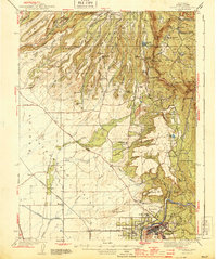
1944 Map of Oroville
USGS Topo · Published 1944About this map
North Table Mountain and South Table Mtn dominate this 1940s landscape, providing a dramatic backdrop to the gold-mining and hydroelectric infrastructure of the Feather River canyon. The map reveals the intricate water management systems of the era, from the Concow Res to several strategically placed Power House facilities. Hard rock and placer mining history is evident in the presence of the Bumble Bee Mines and the New Era Mine, while the town of Oroville serves as the regional hub at the convergence of the Southern Pacific, Northern, and Western Pacific railroads.
Find a feature on this map
105 named features on this map. Tap any name to fly to it.
Don’t see what you’re looking for? This feature index may not catch every label — zoom into the map to look around manually.
Map Details
Editions of this 1944 Oroville Map
2 editions found
Other maps of this area

1888 · Marysville
USGS Topo · 1:125,000

1888 · Smartsville
USGS Topo · 1:125,000

1888 · Bidwell Bar
USGS Topo · 1:125,000

1891 · Bidwell Bar
USGS Topo · 1:125,000

1891 · Chico
USGS Topo · 1:125,000

1891 · Marysville
USGS Topo · 1:125,000

1891 · Smartsville
USGS Topo · 1:125,000

1892 · Smartsville
USGS Topo · 1:125,000

1893 · Chico
USGS Topo · 1:125,000

1893 · Bidwell Bar
USGS Topo · 1:125,000