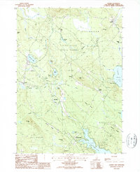
1987 Map of Ossipee
USGS Topo · Published 1987About this map
The Pine River meanders through a landscape defined by glacial deposits and expansive water bodies in this late twentieth-century study of Carroll County. Notable settlements such as Ossipee, North Wakefield, and Center Effingham anchor the regional survey, while smaller localities like Leighton Corners and Grape Corner provide fine-scale detail for local history. The presence of numerous Cemeteries and the industrial footprint of various sand and gravel pits suggest a long-standing pattern of rural life and resource extraction. Significant water features including Duncan Lake, Pine River Pond, and the shared border at Province Lake dominate the eastern and southern portions of the map.
Find a feature on this map
52 named features on this map. Tap any name to fly to it.
Don’t see what you’re looking for? This feature index may not catch every label — zoom into the map to look around manually.
Map Details
Editions of this 1987 Ossipee Map
This is the sole edition of this map. No revisions or reprints were ever made.
Other maps of this area

1891 · Newfield
USGS Topo · 1:62,500

1893 · Newfield
USGS Topo · 1:62,500

1910 · Kezar Falls
USGS Topo · 1:48,000

1911 · Kezar Falls
USGS Topo · 1:62,500

1928 · Wolfeboro
USGS Topo · 1:62,500

1930 · Ossipee Lake
USGS Topo · 1:62,500

1933 · Newfield
USGS Topo · 1:48,000

1937 · Newfield
USGS Topo · 1:62,500

1942 · Newfield
USGS Topo · 1:62,500

1944 · Newfield
USGS Topo · 1:62,500