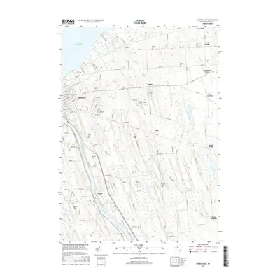
2016 Map of Oswego East
USGS Topo · Published 2016About this map
Oswego and its eastern surroundings occupy a strategic position where the Oswego River meets Lake Ontario. This 2016 survey shows the transition from the city's grid-patterned streets, such as E Seneca St and E Utica St, into the rural landscape of Oswego County. Numerous family and community burial grounds, including South Road Rural Cem, Riverside Cem, and Kingdom Cem, are scattered across the terrain, offering significant touchstones for genealogical research in the town of Scriba and the hamlet of Minetto. The landscape is defined by drumlin-like ridges such as Dutch Ridge and Deer Ridge, which run parallel to the river and influence the placement of historic farmsteads and crossroads settlements like Lansing and Jones Corners. The lakefront is marked by community beaches and points including Jo Lo Shores and Lange Beach Rd, reflecting the area's long-standing connection to the Great Lakes shoreline.
Find a feature on this map
135 named features on this map. Tap any name to fly to it.
Don’t see what you’re looking for? This feature index may not catch every label — zoom into the map to look around manually.
Map Details
Editions of this 2016 Oswego East Map
This is the sole edition of this map. No revisions or reprints were ever made.
Other maps of this area

1900 · Oswego
USGS Topo · 1:62,500

1900 · Fulton
USGS Topo · 1:62,500

1943 · Oswego East
USGS Topo · 1:31,680

1943 · New Haven
USGS Topo · 1:31,680

1943 · Oswego West
USGS Topo · 1:31,680

1943 · Texas
USGS Topo · 1:31,680

1943 · Pennellville
USGS Topo · 1:31,680

1943 · Hannibal
USGS Topo · 1:31,680

1943 · West Of Texas
USGS Topo · 1:31,680
1943 · Fulton
USGS Topo · 1:31,680