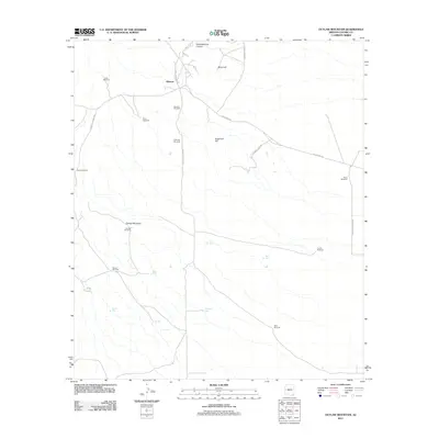
2011 Map of Outlaw Mountain
USGS Topo · Published 2011About this map
Gleeson sits at the northern edge of this landscape, where the naming of N Ghost Town Trl hints at the mining history that once defined this portion of Cochise County. The terrain is dominated by prominent rises such as Maud Hill and Sugarloaf Hill, with the namesake Outlaw Mountain rising to the west. This is a land shaped by the search for water in an arid environment, evidenced by a dense network of specialized infrastructure including Little Windmill, River Windmill, and Coyote Windmill. Smaller water catchments like Mesquite Tank and Frog Lake are scattered throughout, supporting the local cattle operations at Harmon Ranch. The road network, featuring W Gleeson Rd and N High Lonesome Rd, connects these isolated outposts across the desert floor.
Find a feature on this map
29 named features on this map. Tap any name to fly to it.
Don’t see what you’re looking for? This feature index may not catch every label — zoom into the map to look around manually.
Map Details
Editions of this 2011 Outlaw Mountain Map
This is the sole edition of this map. No revisions or reprints were ever made.
Other maps of this area

1916 · Pearce
USGS Topo · 1:125,000

1922 · Swisshelm
USGS Topo · 1:62,500

1925 · Gleeson
USGS Topo · 1:62,500

1926 · Light
USGS Topo · 1:62,500

1926 · Courtland
USGS Topo · 1:62,500

1955 · Douglas
USGS Topo · 1:250,000
1957 · Hay Mountain
USGS Topo · 1:24,000

1958 · Squaretop Hills
USGS Topo · 1:62,500

1958 · Swisshelm Mtn
USGS Topo · 1:62,500

1958 · Pearce
USGS Topo · 1:62,500