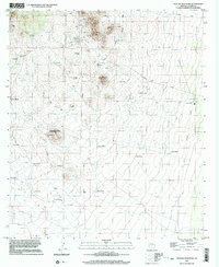
1996 Map of Outlaw Mountain
USGS Topo · Published 2003About this map
Gleeson anchors the northern portion of this landscape, reflecting a history tied to the surrounding mineral riches as evidenced by numerous Mine Shafts and a Quarry near Maud Hill. The settlement's past is further grounded by the local Cem and its connection to the transport network via Gleeson Road. Much of the quadrangle is defined by an arid ranching economy, where survival is marked by a network of water sources including the River Windmill, Coyote Windmill, and Mesquite Tank. An Old Railroad Grade traces a path through the eastern flats, signaling a shift in the region's transport infrastructure. Rugged landmarks like Outlaw Mountain and Sugarloaf Hill rise above the basin, providing orientation across a terrain otherwise dotted with cattle tanks and remote outposts like Harmon Ranch.
Find a feature on this map
30 named features on this map. Tap any name to fly to it.
Don’t see what you’re looking for? This feature index may not catch every label — zoom into the map to look around manually.
Map Details
Editions of this 1996 Outlaw Mountain Map
This is the sole edition of this map. No revisions or reprints were ever made.
Other maps of this area

1916 · Pearce
USGS Topo · 1:125,000

1922 · Swisshelm
USGS Topo · 1:62,500

1925 · Gleeson
USGS Topo · 1:62,500

1926 · Light
USGS Topo · 1:62,500

1926 · Courtland
USGS Topo · 1:62,500

1955 · Douglas
USGS Topo · 1:250,000
1957 · Hay Mountain
USGS Topo · 1:24,000

1958 · Squaretop Hills
USGS Topo · 1:62,500

1958 · Swisshelm Mtn
USGS Topo · 1:62,500

1958 · Pearce
USGS Topo · 1:62,500