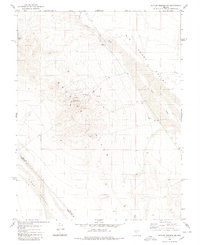
1980 Map of Outlaw Springs NE
USGS Topo · Published 1980About this map
The Royston Hills dominate this high-desert landscape in central Nevada, marking the transition between the Big Smoky Valley to the northeast and Cirac Valley to the southwest. Surveyed in the mid-1970s, this area reflects the scattered industrial activity characteristic of the Great Basin, where exploratory Drill Holes and isolated Prospects are linked by a network of Jeep Trails. Evidence of more established extraction is visible in the southeastern portion of the hills near the Mines and various Gravel Pits. The arid terrain is defined by ephemeral drainages such as Ione Wash and Cloverdale Creek, with a solitary Water Tank serving as a primary landmark in the western flats. The boundary between Nye County and Esmeralda County bisects the southern reaches of the quadrangle, cutting through the southern slopes of the range.
Find a feature on this map
15 named features on this map. Tap any name to fly to it.
Don’t see what you’re looking for? This feature index may not catch every label — zoom into the map to look around manually.
Map Details
Editions of this 1980 Outlaw Springs NE Map
This is the sole edition of this map. No revisions or reprints were ever made.
Other maps of this area

1907 · Tonopah
USGS Topo · 1:250,000

1908 · Tonopah
USGS Topo · 1:250,000

1956 · Tonopah
USGS Topo · 1:250,000

1959 · Tonopah
USGS Topo · 1:250,000

1962 · Tonopah
USGS Topo · 1:250,000

1964 · San Antonio Ranch
USGS Topo · 1:62,500

1980 · Cole Spring
USGS Topo · 1:24,000
1980 · Cloverdale Ranch
USGS Topo · 1:24,000
1980 · Outlaw Springs SE
USGS Topo · 1:24,000

1980 · Secret Basin
USGS Topo · 1:24,000