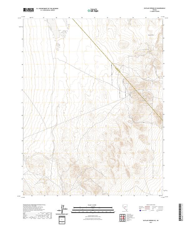
2021 Map of Outlaw Springs SE
USGS Topo · Published 2021About this map
Royston Hills dominates the northeastern landscape of this high-desert region, where the county boundary between Nye Co and Esmeralda Co cuts diagonally across the terrain. The map captures the transition from the upland ridges into the broad expanse of the Big Smoky Valley to the southeast. This modern topographical survey reveals the remote character of this Great Basin environment, defined by its complex drainage patterns and shifting elevations rather than permanent settlements. The cadastral grid of t6n r39e and t5n r40e provides a precise framework for understanding the land divisions in this sparsely populated portion of Nevada, useful for tracing mining claims or historic ranching boundaries in a landscape where few man-made landmarks exist.
Find a feature on this map
7 named features on this map. Tap any name to fly to it.
Don’t see what you’re looking for? This feature index may not catch every label — zoom into the map to look around manually.
Map Details
Editions of this 2021 Outlaw Springs SE Map
This is the sole edition of this map. No revisions or reprints were ever made.
Other maps of this area

1907 · Tonopah
USGS Topo · 1:250,000

1908 · Tonopah
USGS Topo · 1:250,000

1956 · Tonopah
USGS Topo · 1:250,000

1959 · Tonopah
USGS Topo · 1:250,000

1961 · Lone Mtn
USGS Topo · 1:62,500

1962 · Tonopah
USGS Topo · 1:250,000

1964 · San Antonio Ranch
USGS Topo · 1:62,500
1968 · Crow Springs
USGS Topo · 1:24,000
1968 · Gilbert
USGS Topo · 1:24,000

1980 · Cole Spring
USGS Topo · 1:24,000