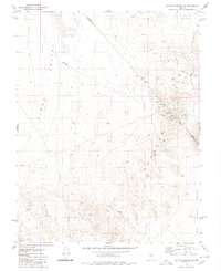
1980 Map of Outlaw Springs SE
USGS Topo · Published 1980About this map
Big Smoky Valley and Cirac Valley dominate this high-desert basin, where the county line between Nye and Esmeralda counties cuts diagonally across the terrain. Mineral exploration is the defining human activity shown in this late 1970s record, with numerous Drill Holes, Prospects, and Mines peppered across the eastern slopes. A network of Jeep Trails provides the primary access into the more elevated regions, particularly around Roys.
Find a feature on this map
13 named features on this map. Tap any name to fly to it.
Don’t see what you’re looking for? This feature index may not catch every label — zoom into the map to look around manually.
Map Details
Editions of this 1980 Outlaw Springs SE Map
This is the sole edition of this map. No revisions or reprints were ever made.
Other maps of this area

1907 · Tonopah
USGS Topo · 1:250,000

1908 · Tonopah
USGS Topo · 1:250,000

1956 · Tonopah
USGS Topo · 1:250,000

1959 · Tonopah
USGS Topo · 1:250,000

1961 · Lone Mtn
USGS Topo · 1:62,500

1962 · Tonopah
USGS Topo · 1:250,000

1964 · San Antonio Ranch
USGS Topo · 1:62,500
1968 · Crow Springs
USGS Topo · 1:24,000
1968 · Gilbert
USGS Topo · 1:24,000

1980 · Cole Spring
USGS Topo · 1:24,000