
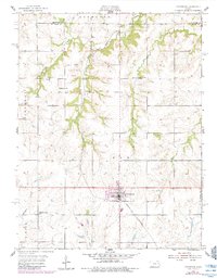
1955 Map of Overbrook
USGS Topo · Published 1956About this map
The Missouri Pacific railroad cuts a diagonal path through the prairie of Osage County, anchoring the town of Overbrook and the smaller siding at Swissvale. This mid-century survey documents a rural landscape transitioning from early settlement patterns to modern agriculture, as seen in the cluster of country schools like Ridgeway Sch, Lickskillet Sch, and Pleasant Valley Sch that once served the outlying farmsteads.
Find a feature on this map
21 named features on this map. Tap any name to fly to it.
Don’t see what you’re looking for? This feature index may not catch every label — zoom into the map to look around manually.
Map Details
Editions of this 1955 Overbrook Map
2 editions found
Other maps of this area

1885 · Lawrence
USGS Topo · 1:125,000

1889 · Burlingame
USGS Topo · 1:125,000

1889 · Lawrence
USGS Topo · 1:125,000

1894 · Burlingame
USGS Topo · 1:125,000

1947 · Lawrence
USGS Topo · 1:250,000

1950 · Lawrence
USGS Topo · 1:250,000
1955 · Clinton
USGS Topo · 1:24,000
1955 · Wakarusa
USGS Topo · 1:24,000

1955 · Carbondale
USGS Topo · 1:24,000

1955 · Globe
USGS Topo · 1:24,000