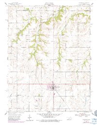
1955 Map of Overbrook
USGS Topo · Published 1983About this map
The Missouri Pacific railroad corridor serves as the primary axis for this portion of eastern Kansas, linking the town of Overbrook with the small stop at Swissvale. The landscape is a network of named townships including Monmouth, Ridgeway, Elk, and Fairfax, where 1950s rural life is anchored by a series of local institutions. Education and community sites are prominently marked, such as the Ridgeway Sch and the distinctively named Lickskillet Sch.
Find a feature on this map
22 named features on this map. Tap any name to fly to it.
Don’t see what you’re looking for? This feature index may not catch every label — zoom into the map to look around manually.
Map Details
Editions of this 1955 Overbrook Map
2 editions found
Other maps of this area

1885 · Lawrence
USGS Topo · 1:125,000

1889 · Burlingame
USGS Topo · 1:125,000

1889 · Lawrence
USGS Topo · 1:125,000

1894 · Burlingame
USGS Topo · 1:125,000

1947 · Lawrence
USGS Topo · 1:250,000

1950 · Lawrence
USGS Topo · 1:250,000
1955 · Clinton
USGS Topo · 1:24,000
1955 · Wakarusa
USGS Topo · 1:24,000

1955 · Overbrook
USGS Topo · 1:24,000

1955 · Carbondale
USGS Topo · 1:24,000