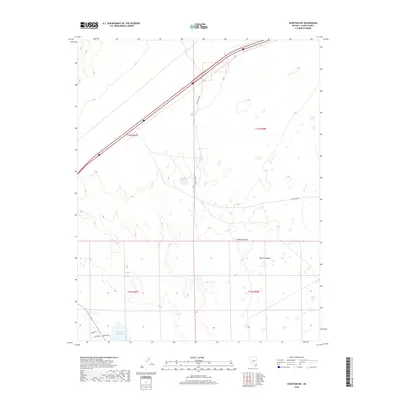
2018 Map of Overton NW
USGS Topo · Published 2018About this map
Mormon Mesa dominates the eastern expanse of this landscape, rising above the arid floor of the Mojave Desert. This 2018 survey reveals a terrain defined by stark topographical transitions and critical water management infrastructure in Clark County. To the southwest, Bowman Reservoir serves as a primary hydrological focal point, supported by local transport routes including Bowman Rd and Canal Ave. The map captures the intersection of natural desert landforms and modern transportation, with the massive transit corridor of Interstate 15 cutting diagonally through the northwest. Historical land divisions like t15s r67e are clearly delineated, providing essential context for understanding land use and property boundaries near the settlement of Bowman.
Find a feature on this map
12 named features on this map. Tap any name to fly to it.
Don’t see what you’re looking for? This feature index may not catch every label — zoom into the map to look around manually.
Map Details
Editions of this 2018 Overton NW Map
This is the sole edition of this map. No revisions or reprints were ever made.
Other maps of this area

1886 · Saint Thomas
USGS Topo · 1:250,000

1893 · Saint Thomas
USGS Topo · 1:250,000

1954 · Las Vegas
USGS Topo · 1:250,000

1957 · Las Vegas
USGS Topo · 1:250,000

1958 · Moapa
USGS Topo · 1:62,500

1958 · Overton
USGS Topo · 1:62,500

1959 · Las Vegas
USGS Topo · 1:250,000

1962 · Las Vegas
USGS Topo · 1:250,000
1969 · Rox SE
USGS Topo · 1:24,000
1969 · Moapa Peak
USGS Topo · 1:24,000