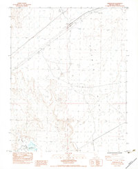
1983 Map of Overton NW
USGS Topo · Published 1983About this map
Mormon Mesa dominates the northern reaches of this desert terrain, where the arid landscape is marked by Dry Lakes and the stark elevation changes above the Moapa Valley. The infrastructure of the early 1980s is defined by linear cuts through the basin, including a major Powerline and a Class 1 Rd that provides access to the Carp Elgin Interchange. Water management in this dry environment is evident through features like the P.E.R. Bowman Reservoir and scattered Stock Tanks, essential for ranching or land use in the high heat. Small-scale industrial activity is also visible near the transport corridors, indicated by several Borrow Pits utilized for road construction and local maintenance.
Find a feature on this map
13 named features on this map. Tap any name to fly to it.
Don’t see what you’re looking for? This feature index may not catch every label — zoom into the map to look around manually.
Map Details
Editions of this 1983 Overton NW Map
This is the sole edition of this map. No revisions or reprints were ever made.
Other maps of this area

1886 · Saint Thomas
USGS Topo · 1:250,000

1893 · Saint Thomas
USGS Topo · 1:250,000

1954 · Las Vegas
USGS Topo · 1:250,000

1957 · Las Vegas
USGS Topo · 1:250,000

1958 · Moapa
USGS Topo · 1:62,500

1958 · Overton
USGS Topo · 1:62,500

1959 · Las Vegas
USGS Topo · 1:250,000

1962 · Las Vegas
USGS Topo · 1:250,000
1969 · Rox SE
USGS Topo · 1:24,000
1969 · Moapa Peak
USGS Topo · 1:24,000