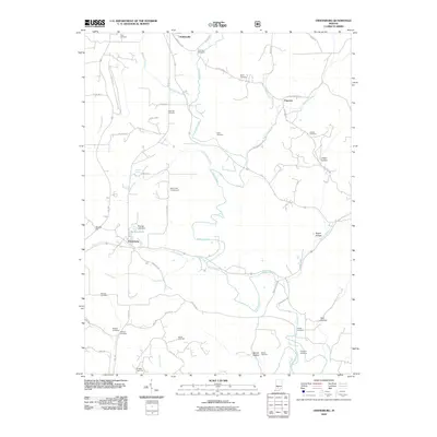
2010 Map of Owensburg
USGS Topo · Published 2010About this map
Owensburg and the surrounding rural landscapes of Greene County are documented in this 2010 survey, showcasing a region defined by its narrow hollows and numerous family cemeteries. The terrain is intricately carved by Indian Creek and its many tributaries, including Popcorn Creek, Mitchell Branch, and Little Indian Creek. Evidence of early settlement and local genealogy is abundant through dozens of burial sites like Dishman Cemetery, Freeman Cemetery, and Dogtrot Cemetery.
Find a feature on this map
61 named features on this map. Tap any name to fly to it.
Don’t see what you’re looking for? This feature index may not catch every label — zoom into the map to look around manually.
Map Details
Editions of this 2010 Owensburg Map
This is the sole edition of this map. No revisions or reprints were ever made.
Other maps of this area

1908 · Bloomington
USGS Topo · 1:48,000

1908 · Bloomfield
USGS Topo · 1:62,500

1910 · Bloomington
USGS Topo · 1:62,500

1935 · Oolitic
USGS Topo · 1:48,000

1942 · Oolitic
USGS Topo · 1:62,500

1953 · Indianapolis
USGS Topo · 1:250,000

1956 · Indianapolis
USGS Topo · 1:250,000
1956 · Clear Creek
USGS Topo · 1:24,000
1956 · Stanford
USGS Topo · 1:24,000

1956 · Koleen
USGS Topo · 1:24,000