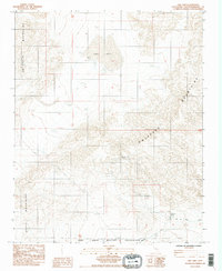
1985 Map of Owl Lake
USGS Topo · Published 1985About this map
The Owl Lake dry bed and the high ridges of the Owlshead Mountains dominate this high-desert landscape in the mid-1980s. A significant portion of the terrain is occupied by the Fort Irwin Military Reservation, with the southern extent marked by the Quail Mountains. The map documents a sparse but industrious mining history, evidenced by the Black Magic Mine and New Deal Mine located within the mountain passes, along with several unnamed prospects. Remote transportation and water sources are vital here, with the Owl Hole Springs Road leading to the critical Owl Hole Springs. The inclusion of the Owl Hole Springs Ruins provides a specific point of interest for researchers tracking early desert habitation and the infrastructure that once supported travelers and miners in this arid environment.
Find a feature on this map
14 named features on this map. Tap any name to fly to it.
Don’t see what you’re looking for? This feature index may not catch every label — zoom into the map to look around manually.
Map Details
Editions of this 1985 Owl Lake Map
2 editions found
Other maps of this area

1933 · Avawatz Mountains
USGS Topo · 1:250,000

1947 · Trona
USGS Topo · 1:250,000

1948 · Trona
USGS Topo · 1:250,000

1948 · Quail Mountains
USGS Topo · 1:62,500

1948 · Leach Lake
USGS Topo · 1:62,500

1950 · Wingate Wash
USGS Topo · 1:62,500

1950 · Confidence Hills
USGS Topo · 1:62,500

1951 · Quail Mountains
USGS Topo · 1:62,500
1951 · Leach Lake
USGS Topo · 1:62,500

1953 · Trona
USGS Topo · 1:250,000