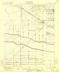
1922 Map of Oxalis
USGS Topo · Published 1936About this map
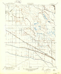
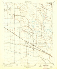
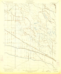
Agricultural and industrial development in the San Joaquin Valley defines this landscape, where the Merced Co Fresno Co boundary crosses a complex network of irrigation and transit. The San Joaquin and Kings River Canal serves as a primary artery for the region’s farming economy, running parallel to the Southern Pacific rail line. This infrastructure supported a variety of specialized agricultural operations, including Holland Farm, Silaxo Farm, and the curiously named Hog Ranch. Near the station at Oxalis, the presence of an Oil Pumping Station alongside the tracks indicates the intersection of petroleum transport with the rural landscape. In the northwest, Dos Palos and the nearby Bryant School anchor the local community, while natural features like Temple Slough and the San Joaquin River provide the vital water resources that transformed this arid valley floor into productive ranch land.
Find a feature on this map
17 named features on this map. Tap any name to fly to it.
Don’t see what you’re looking for? This feature index may not catch every label — zoom into the map to look around manually.
Map Details
Editions of this 1922 Oxalis Map
3 editions found
Other maps of this area

1913 · Panoche
USGS Topo · 1:125,000

1916 · Santa Rita Bridge
USGS Topo · 1:24,000

1916 · Delta Ranch
USGS Topo · 1:24,000

1918 · Bliss Ranch
USGS Topo · 1:31,680

1920 · Santa Rita Bridge
USGS Topo · 1:31,680
1922 · Oxalis
USGS Topo · 1:31,680
1922 · Santa Rita Bridge
USGS Topo · 1:31,680
1922 · Dos Palos
USGS Topo · 1:31,680

1922 · Pozo Farm
USGS Topo · 1:31,680
1922 · Delta Ranch
USGS Topo · 1:31,680