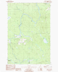
1986 Map of Oxbow East
USGS Topo · Published 1987About this map
The winding Aroostook River defines the landscape of this northern Maine territory, cutting deep meanders that create landmarks like The Oxbow, Pine Island, and the Seven Islands cluster. Settlement is concentrated within Oxbow Plantation, where the village of Oxbow sits near the confluence of Umcolcus Stream and School Bk. The map captures a moment in the mid-1980s when the region's economy relied on timber and gravel, evidenced by the numerous logging trails and the Gravel Pit near the village center.
Find a feature on this map
29 named features on this map. Tap any name to fly to it.
Don’t see what you’re looking for? This feature index may not catch every label — zoom into the map to look around manually.
Map Details
Editions of this 1986 Oxbow East Map
This is the sole edition of this map. No revisions or reprints were ever made.
Other maps of this area

1930 · Greenlaw
USGS Topo · 1:48,000

1931 · Ashland
USGS Topo · 1:48,000

1933 · Greenlaw
USGS Topo · 1:62,500

1934 · Ashland
USGS Topo · 1:62,500

1940 · Oxbow
USGS Topo · 1:62,500

1942 · Oxbow
USGS Topo · 1:62,500

1953 · Ashland
USGS Topo · 1:62,500

1954 · Grand Lake Seboeis
USGS Topo · 1:62,500

1954 · Presque Isle
USGS Topo · 1:250,000

1958 · Presque Isle
USGS Topo · 1:250,000