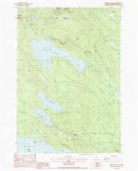
1988 Map of Oxbrook Lakes
USGS Topo · Published 1988About this map
West Musquash Lake and its surrounding glacial terrain dominate this 1988 survey of Washington County, Maine. The landscape is defined by a dense network of water bodies and dramatic topography, including Musquash Mountain and the Pineo Mountains. The connection between Upper Oxbrook Lake and Lower Oxbrook Lake via The Thoroughfare illustrates the natural drainage patterns that have historically shaped local navigation and recreation.
Find a feature on this map
42 named features on this map. Tap any name to fly to it.
Don’t see what you’re looking for? This feature index may not catch every label — zoom into the map to look around manually.
Map Details
Editions of this 1988 Oxbrook Lakes Map
This is the sole edition of this map. No revisions or reprints were ever made.
Other maps of this area

1940 · Waite
USGS Topo · 1:62,500

1941 · Scraggly Lake
USGS Topo · 1:62,500

1941 · Big Lake
USGS Topo · 1:62,500

1941 · Wabassus Lake
USGS Topo · 1:62,500

1942 · Waite
USGS Topo · 1:62,500

1943 · Big Lake
USGS Topo · 1:62,500

1943 · Wabassus Lake
USGS Topo · 1:62,500

1944 · Scraggly Lake
USGS Topo · 1:62,500

1952 · Big Lake
USGS Topo · 1:50,000

1953 · Wabassus Lake
USGS Topo · 1:62,500